Arid agricultural archive

Ravat, south-western Kyrgyzstan

A preserved system of irrigation canals, terraced fields and settlement areas reveals how prehistoric communities managed limited water resources on the margin of the Fergana Basin.

Key findings

Key findings

01

Water was shared infrastructure

What the study foundThe research documented more than 25 km of irrigation canals, over 90 fields and 45 homesteads connected to the same system.

Why it mattersPrehistoric households cultivated their own plots, but seasonal water had to be distributed across a coordinated landscape.

02

Fertilisation practices remained written in soil

What the study foundPrehistoric soils differ chemically from Soviet-period and modern fields and preserve evidence of long-term, low-intensity organic fertilisation.

Why it mattersSoil retains information about everyday land management even where fields were reused in several historical periods.

03

The landscape changed and was reused

What the study foundIsotopes in part of the prehistoric field system indicate C₄ plant input compatible with millet, while other evidence documents later reuse of the system.

Why it mattersInstead of a simple story of “rise and collapse”, the landscape records repeated transformation and reuse of agricultural infrastructure.

Source: peer-reviewed studyDOI ↗
Where Batken Region, Kyrgyzstan
Environment alluvial fan below the Shadymyr Mountains
Chronology 5th century BCE to 6th century CE
Archive canals, fields, soils and settlement areas
Methods UAV, GIS, pXRF, grain size, MS, C/N and isotopes

Landscape setting

Agriculture dependent on seasonal water

Ravat lies on an alluvial fan at approximately 1,700 m a.s.l. Agriculture depended on spring snowmelt and short-lived surface runoff from the Shadymyr Mountains.

  • more than 25 km of irrigation canals
  • over 90 fields covering approximately 60 ha
  • 45 enclosed homestead and settlement areas
  • a central tepe with a monumental adobe structure
  • a hierarchical network of primary, secondary and feeder canals

What we study here

1 / Water

Shared irrigation

We examine how communities captured seasonal runoff and distributed it among fields without a large centrally managed hydraulic system.

2 / Soil

Record of land management

We compare soil signatures of prehistoric farming, Soviet collective agriculture and modern cultivation.

3 / Landscape

Transformation of the agricultural system

We investigate whether abandonment represented a sudden collapse or gradual reorganisation followed by the later reuse of parts of the system.

Results in brief

Davan/Dayuan

The preserved agricultural landscape is tentatively associated with the broader Davan/Dayuan horizon, approximately from the 5th century BCE to the 6th century CE.

Prehistoric farming

The fields were repeatedly maintained, reactivated and locally reorganised. Their soils preserve evidence of long-term organic fertilisation, probably combining ash and animal excrement.

Later reuse

Radiocarbon evidence documents later activity that may also relate to the Kokand period. The development indicates gradual transformation rather than sudden collapse.

Soviet and modern agriculture

Soils from the sovkhoz period and modern fields differ markedly from prehistoric fields. They record mechanical disturbance, mineral fertilisation and different management practices.

Human Earth Lab contribution

Our laboratory contributed the analysis and interpretation of C/N and stable carbon and nitrogen isotopes.

δ¹⁵N

Evidence of organic fertilisation

Prehistoric fields have statistically higher δ¹⁵N values than Soviet and modern fields. Most samples correspond to an isotopic signal associated with manure or animal-excrement inputs.

The results support long-term organic fertilisation and possibly the temporary use of fields as animal enclosures. They do not, however, demonstrate a single specific management practice.

δ¹³C

Different plant inputs

Two of the three investigated prehistoric fields contain a stronger C₄ plant signal. In the regional context, this result is consistent with millet cultivation.

The third field is more consistent with C₃ plants. Because soils, rather than crop remains, were analysed, the isotopic values alone cannot identify a particular cultivated species.

What the isotopes show together

Variation in C/N, δ¹³C and δ¹⁵N shows that prehistoric fields received organic material less uniformly than later agricultural systems. The soils therefore preserve differences between long-term prehistoric maintenance and more standardised Soviet and modern farming.

New study in Catena

Written in the soil: Record of prehistoric subsistence agriculture in semi-arid foothills of Tien Shan, SW Kyrgyzstan

Catena 273 (2026), 110474

The study combines remote sensing, UAV documentation, field survey, GIS and geoarchaeological analyses. Human Earth Lab contributed the analysis and interpretation of stable carbon and nitrogen isotopes.

The full article is freely available through the author link until 18 September 2026.

remote sensing UAV GIS pXRF grain size magnetic susceptibility C/N δ¹³C / δ¹⁵N radiocarbon dating

DOI: 10.1016/j.catena.2026.110474

Abstract

Published abstract

Water management was an essential for sustained agricultural production in the semi-arid regions of Central Asia. Ravat in south-western Kyrgyzstan has abandoned, well-preserved medium-scale irrigation system in Inner Asia. Using remote sensing, UAV-based documentation, field reconnaissance, geoarchaeological sampling and GIS analysis, we identified a central tepe with a monumental adobe structure, more than 25 km of canals forming a network of channels of different sizes, over 90 fields covering 60 ha, and 45 homestead enclosures integrated into the canal system.

The present-day Ravat occupies the central part of this landscape and probably overlies the core of an earlier settlement. The preserved agrarian layout is tentatively attributed to the broader Davan/Dayuan horizon, broadly dated between the fifth century BCE and the sixth century CE. Prehistoric fields were repeatedly maintained, reactivated and locally reorganized.

Soil properties suggest long-term specific fertilization, possibly using ash application combined with temporary use of fields as stables, i.e., fertilization with excrement. Following the end of the primary Davan/Dayuan-period horizon, parts of the landscape may have continued to be reused or reactivated on a smaller scale. Later historical activity, possibly including the Kokand period, is indicated by radiocarbon evidence from selected features. Abandoning suggests gradual transformation rather than sudden collapse.

Soils from the sovkhoz-period as well as soils detected in modern fields differ significantly from prehistoric ones. Sovkhoz-period soils also reflect disturbance caused by the ploughing of burial mounds located within parts of the former field system, as well as the use of saltpeter fertilizer mixed with dolomite and applied by aircraft. The pedological record of modern fields reflects the use of pure saltpeter fertilizer applied at ground level on soils not previously cultivated in prehistoric times.

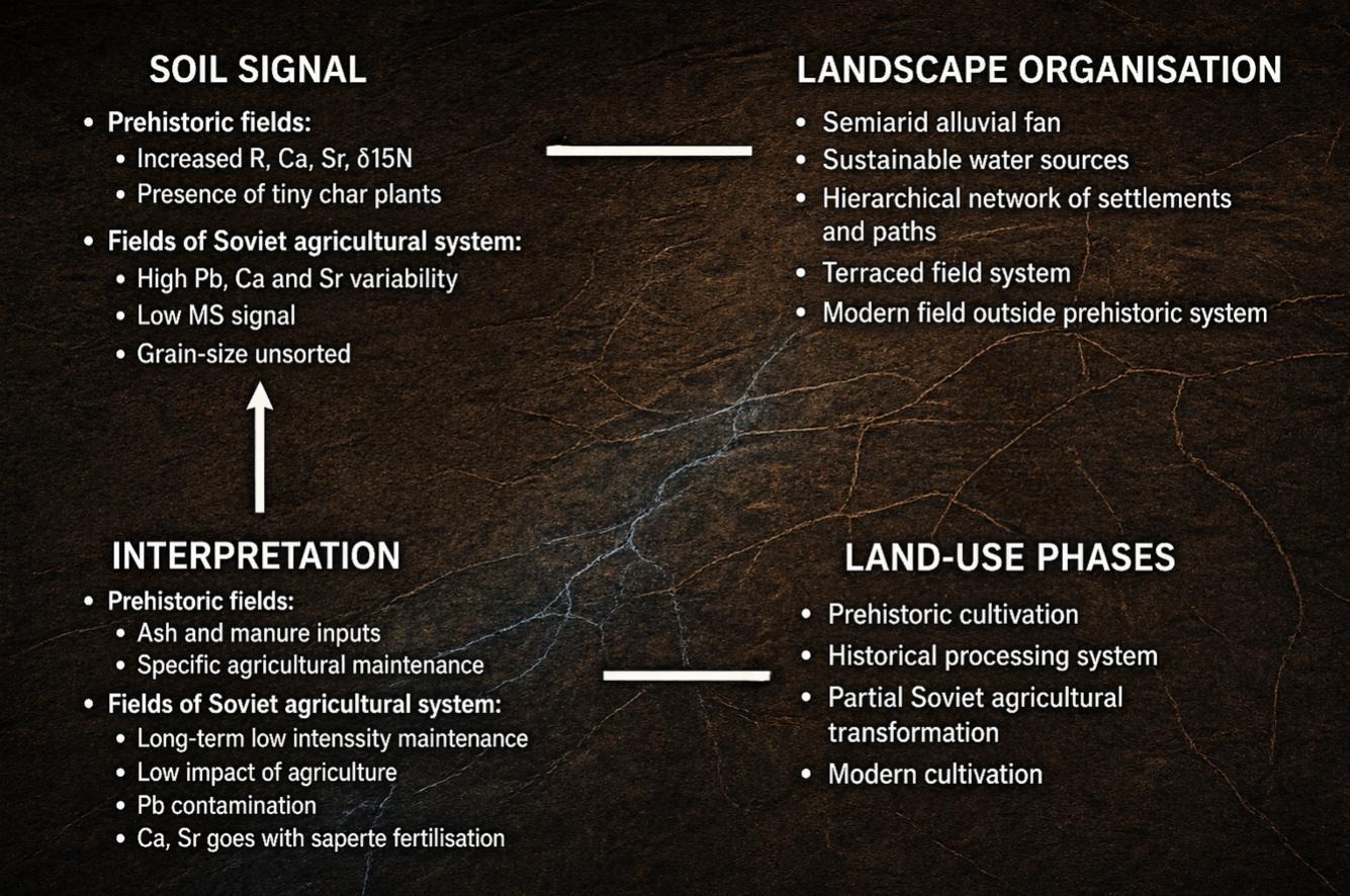
Study results at a glance

Soil signals, land-use phases and organisation of the agricultural landscape at Ravat
Soil signals, land-use phases and spatial organisation of the agricultural landscape at Ravat. Prehistoric fields differ from Soviet and modern fields in their geochemical, magnetic and isotopic records.
Source: Vatansever et al. 2026, Catena 273, 110474, graphical abstract. © 2026 Elsevier B.V.

Interpretation for Human Earth Lab

Soil as a record of land management

Soil records more than whether land was cultivated. It also preserves organic inputs, the probable range of crops, the duration of land use and differences between prehistoric, Soviet and modern agriculture.

Ravat shows that a medium-scale irrigation system could operate over the long term in a semi-arid environment through shared water management and cultivation by individual households. Its development represents the gradual transformation of a multi-phase agricultural landscape rather than a single cycle of growth and sudden collapse.

Team and outputs

Team

Study authors

Atilla Vatansever, Lenka Lisá, Martin Janovský, Abdinabi Kadyrov, Jakub Trubač, Jozef Chajbullin Koštial, Libor Petr, Aleš Bajer, Ivo Světlík, Pavel Lisý, Petr Kočár and Kadicha Iskandarovna Tashbaeva.

Long-term research

Central Asian Research Society

Research at Ravat forms part of the long-term study of archaeological landscapes in Kyrgyzstan. It combines landscape archaeology, geoarchaeology, soil science, remote sensing, isotope analysis and radiocarbon dating.

archeo.kg